
ETOSHA TRAVEL TIPS
Etosha Map: Download, Read and Use It to Plan Better Routes
A good Etosha map shows where roads, gates, camps, waterholes and facilities relate to one another. It does not tell you how long wildlife, dust, closures or a changing road will make the journey.
Download the map before travel, keep an offline copy and confirm current access and operating times locally.
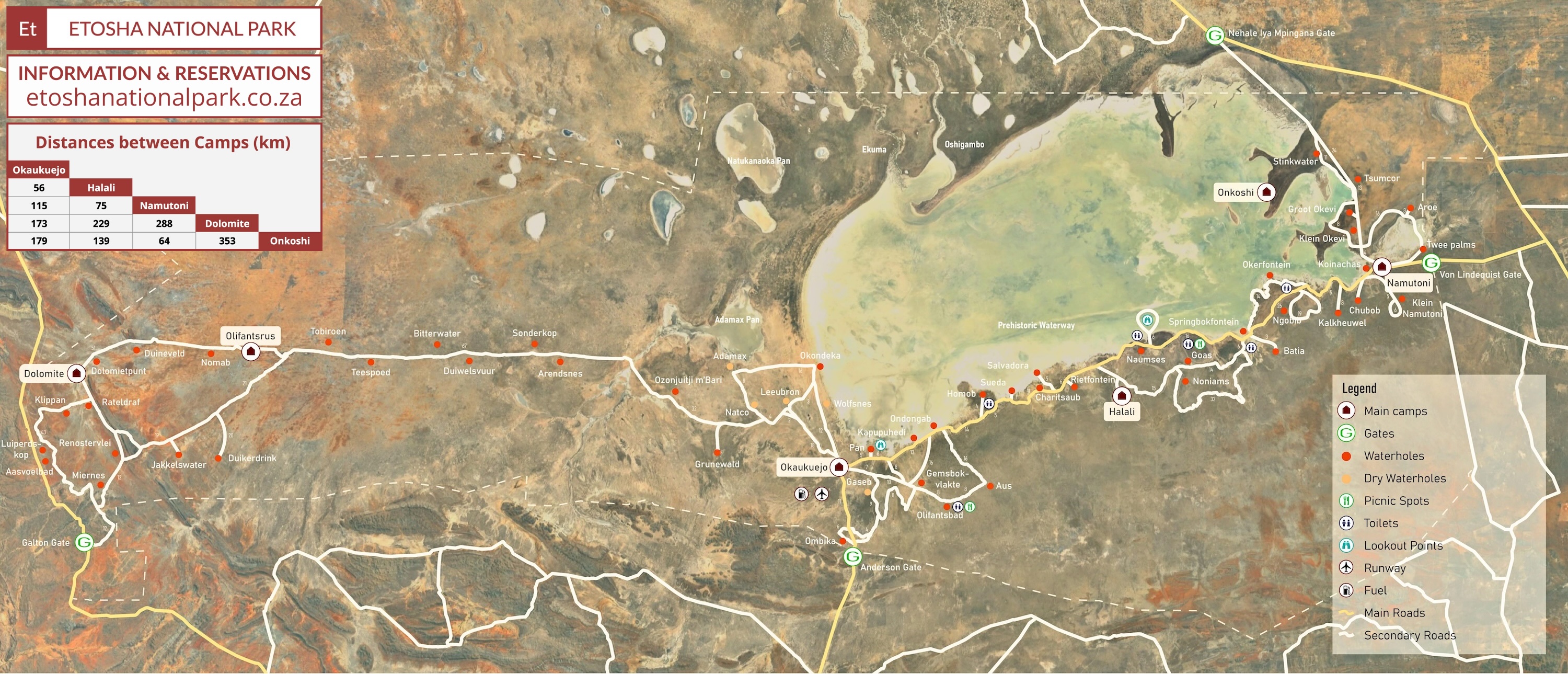

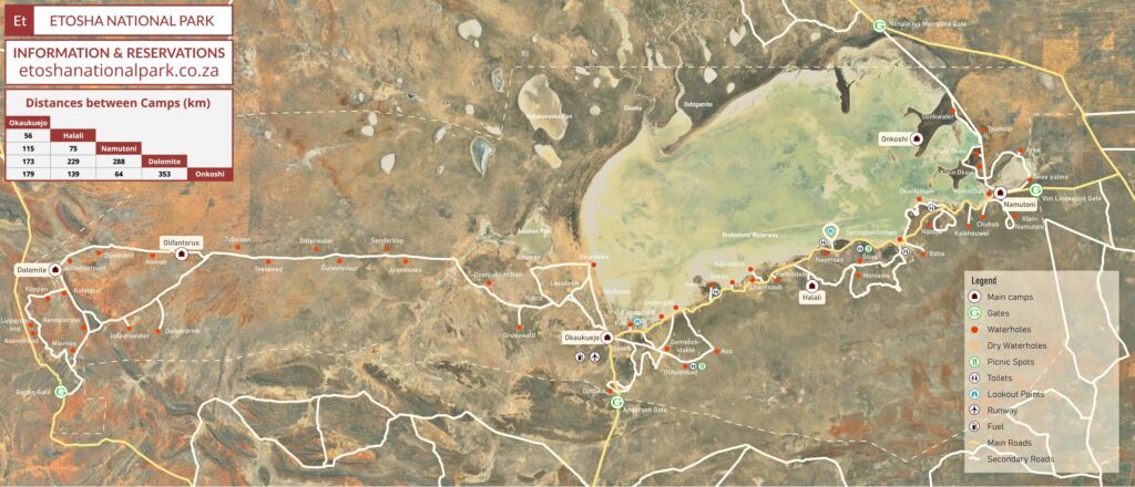
DOWNLOADABLE ETOSHA MAP
Keep a full-resolution map available before you enter the park
Use the JPG for quick offline viewing and the PDF when you want a document that is easier to save or print. Check the file and downloads before leaving dependable internet.
HOW TO READ THE MAP
Start with gates, camps and road connections before looking at waterholes
A map becomes useful when it answers three questions: where will you enter, where must you finish and which legal roads create a comfortable loop between them?
GATES
Identify the correct entrance and exit
A gate on the map may not suit the wider route or current operating plan. Confirm access before travel.
CAMPS
Use accommodation as the daily anchor
Mark the camp or lodge first, then judge every proposed loop by the safe return.
ROAD TYPE
Distinguish connections from destinations
A road is not just a line between labels; it passes through habitat where most sightings may occur.
WATERHOLES
Treat symbols as possible stops
A mapped waterhole does not guarantee current water, access or wildlife.
FACILITIES
Locate designated places for breaks
Know where toilets, picnic areas and authorised exit points fit into the route.
ORIENTATION
Use major landscape features
Pan edges, camps and junctions help confirm position when a smaller sign is missed.
DISTANCE IS NOT DRIVING TIME
Convert kilometres into conservative safari time
Etosha driving is intentionally slow. Road surface, dust, animals and observation stops make ordinary road calculations unreliable.
SPEED
Never calculate from the posted maximum
The limit is not an average and many conditions require substantially slower travel.
SIGHTINGS
Budget for the reason you came
A meaningful encounter can hold the vehicle for far longer than an ordinary stop.
DUST
Increase following distance
Visibility and overtaking opportunities may disappear behind traffic.
JUNCTIONS
Allow for navigation checks
Stopping safely to confirm the route is better than correcting a long wrong turn.
BREAKS
Include designated rest time
Fatigue reduces observation and driving quality.
BUFFER
Protect the final hour
A route without contingency invites speeding and late arrival.
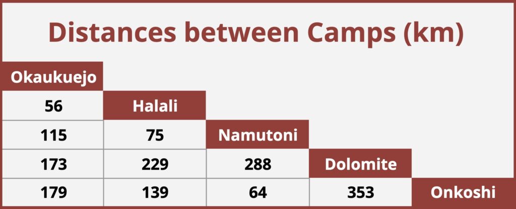
GATES, CAMPS & DAILY ANCHORS
Build the itinerary from fixed points before adding optional loops
The map helps connect entrances and accommodation, but current gate times, check-in details and road conditions determine what is practical.
SOUTHERN APPROACH
Match the entrance to the wider road journey
Do not choose a gate solely because it looks closest to a waterhole.
EASTERN APPROACH
Use eastern camps for regional exploration
Woodland, pan-edge routes and eastern waterholes can form complete days without crossing the entire park.
CENTRAL BASE
Use Halali to divide longer itineraries
A central overnight can reduce backtracking and support different loops on consecutive days.
WESTERN ROUTES
Confirm access and accommodation rules
Do not assume every western road or facility is available under the same conditions.
NORTHERN ACCESS
Check the current operating context
An entrance may suit a particular regional itinerary while adding complexity to another.
MULTI-CAMP STAY
Treat transfer days as game drives
Keep the route conservative so wildlife stops do not threaten arrival deadlines.
BUILD A WORKABLE ROUTE
Use the map to design a day that leaves room for wildlife
The best route is rarely the one that touches the most roads. It is the one that protects your gate or camp deadline while giving you time to stop, watch and change course.
START WITH ANCHORS
Mark the non-negotiable points first
Place your entrance gate, overnight camp and required exit on the map before choosing any detours. These anchors determine how much freedom the day really contains.
CREATE A CORE LOOP
Choose one realistic main circuit
Build a route you can complete comfortably even if sightings slow you down. Treat extra waterholes and side roads as optional additions rather than obligations.
ADD TURNAROUNDS
Know where you can shorten the day
Identify junctions that let you return directly to camp or the gate. A planned turnaround prevents a late-afternoon sighting from turning into a rushed final drive.
ALLOW WATCHING TIME
Budget for stillness, not only kilometres
A productive waterhole stop may last far longer than expected. Leave open time for elephants, predators or unusual behaviour instead of scheduling every minute.
MATCH THE SEASON
Adjust the route to current conditions
Dry-season concentration, summer rain, road condition and vegetation can change which areas deserve attention. Ask locally before locking in your circuit.
KEEP ONE BACKUP
Prepare a shorter alternative
If weather, road closures or slow sightings disrupt the plan, a simple backup route lets you adapt without improvising under deadline pressure.
NAVIGATE OFFLINE
Prepare for weak signal before you enter
Mobile reception is not a reliable navigation strategy inside a large wildlife reserve. Carry a usable offline reference and make sure everyone in the vehicle understands the day’s route.
DOWNLOAD A COPY
Save the map before departure
Keep the map on at least one fully charged phone or tablet. Open it once while connected so you know the file works without data.
CARRY PAPER
Take a printed map as a backup
A paper copy remains useful when a battery fails, a screen overheats or glare makes a phone difficult to read. Mark camps, gates and the planned turnaround points.
USE ROAD SIGNS
Treat signs as the primary on-site guide
Follow official signs and current instructions even when a digital map disagrees. Physical access, closures and one-way restrictions may have changed.
RESET AT JUNCTIONS
Confirm direction before moving on
At every major junction, compare the sign, map and intended destination. A thirty-second check is easier than recovering from a long wrong turn.
SHARE THE PLAN
Let a passenger help navigate
A second person can track junctions, distances and time while the driver watches the road and wildlife. Solo drivers should stop only at authorised places before checking details.
PROTECT BATTERY
Reduce avoidable power use
Carry a vehicle charger or power bank, lower screen brightness and close unnecessary apps. Navigation is more valuable late in the day than another hour of background use.
WHAT A MAP CANNOT TELL YOU
Verify anything that can change
Use this map for orientation, not as a guarantee of live conditions. Access, opening times, water availability and road status can change faster than a downloadable map.
OPENING TIMES
Check the day’s official times
Gate and camp schedules can vary by season and operational circumstances. Confirm them locally and plan to arrive with a generous margin.
ROAD STATUS
Ask about closures and restrictions
Rain, maintenance, wildlife management or safety concerns may temporarily close a road. Never bypass a barrier or assume an older route is still open.
WATER CONDITIONS
Do not equate a symbol with water
A named waterhole may be dry, quiet or inaccessible. Recent local information and patient observation are more useful than a fixed promise.
FUEL & SERVICES
Confirm availability before relying on it
Facilities can have limited hours, stock interruptions or technical problems. Refuel early and carry enough drinking water for the route.
TRAVEL PERMISSIONS
Check access beyond the main public network
Some areas may require bookings, guides, permits or specific accommodation arrangements. Do not infer public access from a line shown on a map.
CURRENT RULES
Follow instructions issued inside the park
Official signs and staff directions take precedence over this guide. Conditions can change, and the safest route is always the authorised one.
MAP-READY CHECKLIST
Set up the route before the gate opens
A few minutes of preparation creates a calmer safari day. Complete these checks the evening before or before joining the entrance queue.
DOWNLOAD
The map is saved offline
Open the file once and zoom in to confirm it is readable without mobile data.
A paper backup is in the vehicle
Keep it protected from dust and drinks, with the day’s key points marked.
ANCHORS
Entry, camp and exit are identified
Everyone should know where the drive begins and where it must finish.
TIMES
Current gate or camp times are confirmed
Use today’s official information, not a screenshot or recollection from a previous trip.
CORE ROUTE
The main loop is realistic
Choose fewer stops and allow time for sightings, traffic and rougher road sections.
TURNAROUND
A latest turnaround point is agreed
Set a place and time for shortening the route before the day becomes rushed.
BACKUP
A shorter route is ready
Know which junction gives the simplest return if conditions or sightings change the plan.
POWER
Phone, charger and power bank are ready
Keep the navigation device shaded and reserve enough battery for the late afternoon.
ETOSHA MAP FAQ
Answers to practical route-planning questions
These are the questions travellers most often ask when turning a park map into a safe, enjoyable self-drive itinerary.
MAP FORMAT
Can I download and print this map?
Yes. Use the JPG for quick viewing and the PDF for a cleaner printable copy. Check the file before leaving reliable internet access.
PHONE USE
Will the map work without mobile reception?
A downloaded image or PDF will, but live map features may not. Save it locally and carry a paper backup.
DRIVE TIMES
Can I calculate the day from distance alone?
No. Gravel surfaces, wildlife stops, road conditions and viewing time make park travel much slower than ordinary road travel.
WATERHOLES
Does every marked waterhole have water?
No. Water levels, access and wildlife activity vary. Treat each one as a possible stop, not a guaranteed sighting.
GPS
Should I follow GPS directions inside Etosha?
Use GPS only as a secondary reference. Official signs, open roads and staff directions must always take priority.
ONE-DAY VISIT
How much of the park can I cover in one day?
Less than the map suggests if you want a rewarding safari. Focus on one coherent area instead of attempting a rushed cross-park checklist.
MULTI-CAMP TRIP
How should I plan a transfer day?
Make the destination camp your anchor, choose a conservative route and treat optional loops as additions only if time remains.
LATEST INFORMATION
Where should I confirm changes?
Check current instructions with authorised park staff, your accommodation or official visitor information when you enter.
SAVE THE MAP, THEN BUILD A REALISTIC DAY
Turn the map into an Etosha itinerary you can actually enjoy
Choose your gates and camps first, keep daily loops conservative and leave enough time for the sightings that make the journey worthwhile.